Excellent use of Arduplane
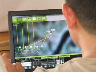
Great article on a team using the DIY Drones ArduPilot to monitor deforestation in Sumatra,They are equipped with Arduplane based on the mission planner in use on their laptop, although it is not concerned in this paper.
Using seed funding from the National Geographic Society, The Orangutan Conservancy, and the Denver Zoo, Lian Pin Koh, an ecologist at the ETH Zürich, and Serge Wich, a biologist at the University of Zürich and PanEco, have developed a conservation drone equipped with cameras, sensors and GPS. So far they have used the remote-controlled aircraft to map deforestation, count orangutans and other endangered species, and get a bird’s eye view of hard-to-access forest areas in North Sumatra, Indonesia.
The drone is almost fully autonomous, which means it can take-off and fly on autopilot,” Koh explained. “The user pre-programs each mission on a laptop computer by clicking waypoints along a planned flight path on a Google Map. Based on this flight path and the onboard sensors (GPS, altitude sensor, airspeed sensor, etc), the drone will take off automatically, fly to every waypoint, and then return to the user. During the mission, the drone can take photographs or videos depending on the camera system installed.”
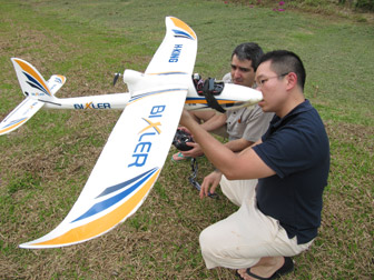
To date, Koh and Wich have used the drone in Aras Napal, close to the Gunung Leuser Conservation Area in Sumatra. During their four days of testing, the drone flew 30 missions — collecting hundreds of photos and hours of video — without a single crash. A mission, which typically lasts about 25 minutes, can cover 50 hectares.
“The drone took pictures of areas where logging occurred, and areas where oil palm are planted right next to a river, which is very damaging to the river ecosystem,” Koh said. “It also took pictures of an orangutan who was feeding on top of a palm tree, as well as elephants on the ground. During one mission, the drone also recorded a video showing smoke rising from a forest area. These test missions demonstrate that the drone can indeed be used for the purposes it has been developed for.”